Catalog Moat Creek Web Images
1-16 | 17-32 | 33-48 | 49-64 | 65-80 | 81-96 | 97-112 | 113-128 | 129-144 | 145-160 | 161-165
Read our email adventures
#1 (April 2004), #2 (July 2004), #3 (Nov 2004) #4
(July 2005) and #5 (April 2006)
or browse these photo stories.
Click on a picture below to view a larger image or click on an index page link
above. ![]()
 |
 |
 |
 |
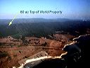
| P9280007-MoatCreekPostcard.jpg View of 80 acre Moat Creek property from Point Arena cape looking south-east (sorry for reflections of plane stuff) 2003:09:28 17:09:57 |
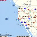
PointArenaWestCoastMap.gif Where Point Arena is located on the West Coast, 520 air miles from San Diego or 3 hours in my plane! |
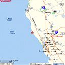
PointArenaNoCalMap.gif Where Point Arena is located in Northern California, about a 3-hour drive north of San Francisco! |
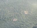
PA120076-MoatCreekProperty.jpeg Aerial view of 80 acre Moat Creek property, outlined in orange, with view of radio tower at peak of ridge, and location of Leon Schneiderman's house off to the south (note orientation matches next topo map image) 2003:10:12 17:25:29 |
 |
 |
 |
 |
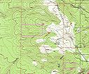
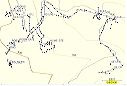
| MoatCreekPropLines-t#37638.jpeg Topo map orientation of 80 acre Moat Creek property to match previous aerial photograph, with property lines in magenta color. |
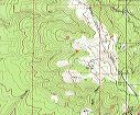
MoatCreek-topo50000.jpg Topo map of 80 acre Moat Creek property area |
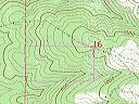
MoatCreekPropLines-to#37637.jpg Topo map of 80 acre Moat Creek property at 1:24,000 scale showing contours from northeast corner where road and powerline cross descending to southwest corner. |
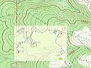
MoatCreekPropLines-merge.jpg Superimposition of GPS walk-about tracks and topo map contours |
 |
 |
 |
 |
| MoatPropertyGPSTopo.jpg GPS walk-about the 80 acre Moat Creek property. Note: we located the NE corner at road/powerline/fence/flat area, NW corner at logging landing, SW corner across a ravine. Also note home site clearning and location of Robin-John house. |
PA120084-Robin80Acre.JPG Aerial photo of southwestern portion o the 80 acre Moat Creek property that shows the Robin-John house (on the wrong side of the property line) and the cleared home site 2003:10:12 17:30:55 |
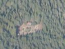
RobbinJohnHomeSite.jpg Robbin-John house located on western boundary of 80 acre Moat Creek property. The boundary goes left-to-right across the garden, placing their home on the wrong side of the property line. 2003:10:12 17:30:55 |
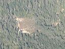
MoatCreekHomeSite.jpg Home site clearning, approximately 1.25 acres, on 80 acre Moat Creek property. There are two level terraces, the top one is where the panorama photomontage was taken. 2003:10:12 17:30:55 |
 |
 |
 |
|
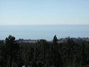
| P1010031-MoatCreekView.JPG View of the ocean from the cleared home site on the 80 acre Moat Creek property. The dip in the sea cliff is where Moat Creek empties out to the ocean. 2004:11:30 08:58:53 |
MoatCreekProp-panorama2000.jpg Panorama of the ocean view from the home site on the 80 acre Moat Creek property (scroll horizontally to view entire panorama). The panorama represents about 270 degrees of circular view, starting from the southeast, to the southwest towards the ocean, and ending due north looking at Robbin and the truck. |
P1010012-RobbinPowerline.JPG Robbin standing on the powerline road at the northeast corner of the Moat Creek property. The NE marker is off to the left of this picture, about 10 feet in front of where Robbin is standing. 0000:00:00 00:00:00 |
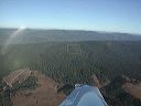
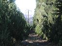
P1010034-PowerLineToPtArena.JPG This powerline road goes from the fence gate to the home site. Off in the distance is the Point Arena lighthouse. 0000:00:00 00:00:00 |
1-16 | 17-32 | 33-48 | 49-64 | 65-80 | 81-96 | 97-112 | 113-128 | 129-144 | 145-160 | 161-165
![]()
![]()