Catalog Moat Creek Web Images
1-16 | 17-32 | 33-48 | 49-64 | 65-80 | 81-96 | 97-112 | 113-128 | 129-144 | 145-160 | 161-165
![]()
 |
 |
 |
 |
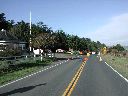
| PC310003-ClosedHighway.JPG Wanna party?! Hoping to drive to a New Year's party, we found Highway One north closed due to flooding. With mud slides blocking the route south, we had no alternate way to get there! 2006:01:01 13:10:15 |
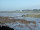
PC310005-FloodedDip.JPG The Garcia River floods Highway One, both here at this dip and a larger section that crosses the fields behind. 2006:01:01 13:15:52 |
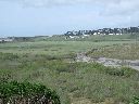
P4010005.JPG For comparision, here is the normal height of a tributary of the river, taken several months later. 2006:04:01 13:48:57 |
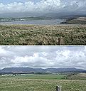
GarciaFloodedAndDry.jpg The Garcia River floods the farm land at the mouth of the river, where it empties into the ocean behind us off to the left of these pictures. We're standing on the road to the Point Arena lighthouse looking eastward back upstream. Highway One curves around the hills and then crosses the farm land to the dairy buildings on the north shore. 2006:04:01 10:33:30 |
 |
|||
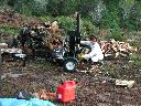
| PC160014-MollyLogSplitter.JPG Molly works her very own log splitter! The pile of rounds were cut from the Bishop Pine trees felled to clear the solar arc. All of the split firewood has been given away to friends who have wood stoves. 2005:12:16 11:23:10 |
1-16 | 17-32 | 33-48 | 49-64 | 65-80 | 81-96 | 97-112 | 113-128 | 129-144 | 145-160 | 161-165
![]()
![]()